
Jerusalem Walking Tour for Chol HaMoed Succos
 |
| View from Yemin Moshe |
Written by: Vardah Littmann.
Photos by Rimonah Traub.
www.israelcamerafocus.blogspot.com
For 19 years Yerushalayim was
a city divided, cut in two by the
1948 armistice after Israel’s
War of Independence.
On November 30, 1948, at the time of the official
cease-fire, Moshe Dayan sat with Abdallah Tell and
UN mediators, slicing up Yerushalayim. Using a map
scaled at 1:20,000, each side used a different colored
wax pen to delineate the furthest point under its
control. Israel drew a red line and Jordan a green
line. This is the origin of the phrase used to describe
 |
Window in Morasha
|
land that is “behind the green line.”
The 1948 armistice line in Yerushalayim stretched
from Armon HaNatziv in the south of Jerusalem to
Ammunition Hill to the north of the City. In many
places the two lines converged. In addition, as the
wax of the China graphic pens dried, the colored
ink lines spread out until they coved two millimeters
of the map which equaled 200 meters. The drying
ink caused a delicate problem concerning where
the exact boundaries were. For example, part of the
neighborhood of Musrara remained in a deadlock
until an agreement was reached in July, 1951.
Mount Scopus, where the Hebrew University
and Hadassah Hospital are situated, remained in
Jewish hands although it was unequivocally within
the Jordanian boundary. Twice a week, our soldiers
disguised as policemen would travel in a convoy in
order to be able to reach Mount Scopus to guard
the area. The original sites of Hebrew University
and Hadassah Hospital were technically under the
protection of the United Nations, but despite the
“Mount Scopus Agreement,” the institutions were
not permitted to reopen.
Jordan was a threatening enemy state. Along the
seam of the division line on the Israeli side, people
lived in danger and anxiety. At any given moment
the trigger-happy Jordanian soldiers might open fire
on innocent civilians. Many times children playing in
 |
Gas station next to the
Liberty Bell Park
|
front of their homes were shot at. Mothers would
scream out to their children to take cover.
As time passed, both sides built walls and fences
for defense and security reasons. The Jordanians
had 36 posts around the City, as compared to
Israel’s 19 .
Our starting point on the walking
tour is the gas station next to the
Liberty Bell Park. We begin our brisk
walk though the suburbs, facing the old
city walls which had been turned into a frontier on
“no-man’s land” from 1948 until 1967.
Our first stop is the Har Tzion Hotel, at the
Cable Car Monument,
cable carDerech Chevron. Here, the Duke of Kent, who  |
| Entrance to Cable Car Monument |
of Saint John of Jerusalem, built a hospice for eye
diseases in the 1880’s. At the time there were
about four hundred different eye afflictions. The
Ottoman army used the building as a weapons
storehouse during the First World War.
During the War of Independence fire from the
Arab League made it impossible to reach positions
on Har Tzion from the west of the City. At first the
connection was maintained by means of a tunnel
though the wadi. The tunnel made it possible to
transfer supplies and evacuate the injured. This
method obviously had its limitations.
A solution was formulated by Uriel Hefetz in
December of 1948. A 200 meter (656 foot) steel
cable was stretched across the Hinnon Valley,
linking the Eye Hospital to the Israeli position
on Har Tzion. It was only used at night, so that
Jordanian Legion soldiers would not notice its
activity. At the end of each night, the cable would
be lowered down into the valley.
The cable car reached a height of about 50
meters (164 feet) above the wadi. The rail cart
could carry a maximum weight of about a half a
ton. Three soldiers on each side were responsible
for operating the cable car manually. The cable car
journey lasted about two minutes in each direction.
Although it was used for only half a year, the IDF
maintained it in perfect working condition from
1948 until 1967, should the need for its use arise
again. The cable car was kept a military secret for
twenty four years, and its existence was
only revealed to the public in 1972.
After using the foot bridge, we
turn right onto an enchanting
 |
| Nachon Street. |
southwest of the Old City) that
leads below Mishkenot Shaananim
and then through its neighboring suburb Yemin
Moshe. Both colonies were built on land
purchased by the British philanthropist Lord Moshe
Montefiore at the prompting of Rav Shmuel Salant,
with funding from an estate left by Mr. Judah
Touro. Mishkenot Shaananim was built in 1855,
and Yemin Moshe was established in 1891.
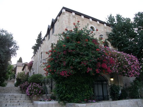
Butterflies flit though the air, and the greenery
is lush. Scarlet and red-pink bougainvillea bushes
 |
| There are 120 steps like these in Yemin Moshe. |
and beautiful flowers line the walkways. To our right in places where the thick vegetation is thinner or lower, we can view the Old City wall built by Sultan Suleiman the Magnificent.
These neighborhoods were attacked in the 1929
Arab riots, but the residents successfully repulsed
the attackers. And during the War of Independence
the whole area was surrounded by the enemy for
months. It held out heroically, but after a heavy
assault in February of 1948, most of the residents
fled.
 The cease-fire lines established following the war
turned the area into a frontier on the “no-man’s
land” of a divided Jerusalem with the border between
Israel and Jordan located in the Hinnon Valley.
During the division period, the Ministry of
Housing settled new olim,
mostly from Turkey, in both
neighborhoods. Snipers on
the Old City walls would
indiscriminately fire at the
residents, causing fear and
chaos.
After the lightning Six Day
War the whole area was
renovated. It was designated
as an artist’s colony, and
 most of the residents who
had suffered through the
19 years of terror were
relocated.
The uniquely beautiful
Beit Yisrael Shul of Yemin
Moshe, founded in 1895 and
maintained throughout the
nearly two decades of the
separation period, was slated to be turned into
an artist gallery and studio. Rav Yehuda Leib
Porush, whose forebearer Rav Shlomo Zalman
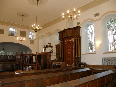 |
| Beit Yisrael Shul |
organized a demonstration of yeshiva boys to
protest the renovation plan.
Eventually, the firm which had been given
rights by Mayor Teddy Kollek to build an
artists’ gallery in this place of worship,
relented. Municipal approval for the renewed
function of Beit Yisrael as a house of prayer
and learning was given. The congregation was
officially reconstituted in 1975, and in 1992,
Rav Chanoch Yeres was engaged to serve the
needs of the English speaking members.
Mishkenot Shaananim and Yemin Moshe are now
upscale neighborhoods where artists work in studios
and sell their work in galleries.
Now we take the winding footpath
that leads us to Mamilla, outside
of Jaffa Gate.
 |
| Mamilla Mall |
Partition Plan, an Arab mob ransacked
and burned much of the Mamilla district and stabbed
some of its Jewish occupants. During the War of
Independence, the neighborhood turned into one
of the main combat zones which led to the flight of
both Jewish and Arab residents. After the Armistice
Agreement gave Israel the western three-quarters
of Mamilla, and the eastern quarter became a “noman’s
land” of barbed-wire and concrete barricades.
Throughout the 19 years of the division of
Jerusalem, Mamilla was subject to stone throwing,
sniper, and guerilla attacks by Arab Legionnaires
from the Old City walls above it. After Israel built
a barrier wall, the area became the home of new
immigrants with large families and small financial
abilities. It also became a center for light industry
such as auto-repair.
After the unification of the city in 1967, the
barricades that had lined Mamilla’s 19 yearold
border were torn down. As a result of the
many years of fighting and the resultant limited
 |
David’s Village,
|
end were in shambles. Several historic buildings had
to be condemned.
In 1972 the city began to develop the
neighborhood. They evicted about 700 families,
as well as communal institutions and businesses.
These families were mostly Jewish immigrants from
Arab states whose weak financial status left them
vulnerable. For 19 years they had suffered as a live
defense barrier. After they were evicted from their
homes there was a steep increase in real-estate
values of this former slum area. This became a key
issue in the Israeli social upheaval of the 1970s and
was one of the causes of the founding of the Black
Panther movement in Israel.
The former Mamilla area, now called David’s
Village, is a luxury neighborhood. The apartments
are mostly owned by people who live overseas
and visit Israel a few times a year which makes it
resemble a ghost town in the city center.
 |
| Musrara |
about seven or eight minutes along
Rechov HaTzanhanim (Paratroopers’
Road) and reach a gem of an area
called Musrara in Arabic. In Hebrew
it’s known as Morasha and is outside
the northwest corner of the Old City.
The part of Musrara (Rechov Ha’ayin Het) we walk
though was established by rich Christian Jordanian
Arabs during the late 19th century. They built large,
luxurious mansions in an attempt to escape the
overcrowding in the Old City. These houses have
grand entrances, beautiful masonry, and shingled
roofs.
Until 1948 the Arabs of Musrara and their Jewish
neighbors lived in peaceful coexistence. When the
war broke out the Jordanian legion used the area to
attack nearby Jewish neighborhoods. This caused an
exchange of population. The original Arabs ran away
 to the Jewish Musrara, and the Jews in the Jewish
area fled to the area where we are walking.
After the armistice, Musrara was divided by a
barbed wire fence between Jordan and Israel. During
the early days of the State there was an extreme
shortage of housing, and the Ministry of Housing
settled olim there, mainly from North African countries.
For 19 years almost daily, the alleyways and stone
courtyards resounded with the thunder of Jordanian
bullets. There were many casualties in Musrara, and
Shabbos morning was the favorite shooting time
for the Jordanian soldiers. This continued until the
reunification of Jerusalem after the Six Day War in
1967.
In the beginning of the 1980s the Jerusalem
 Municipality planned a project to improve the
neighborhood. Regulations were introduced which
were designed to restore the neighborhood to its
former glory. The renovations were all to be done in
the style of the magnificent existing Arab structures.
Unfortunately, on many of these restored buildings, a
clear line can be seen between the lower floors, built
in the Arab style, and the upper floors, which look like
modern apartment buildings.
HaAyin Het Street is named for about 80 innocent people, mostly civilians,including doctors and nurses, who were murdered by Arab forces on April 13, 1948 in a convoy bringing medical supplies and personnel to Hadassah Hospital on Mount Scopus. The massacre was a gross violation of human rights, international militaryconvention, and common decency. Morasha over the last decade, has become more Hareidi. There is a large population of Breslover Chasidim living there.
Our last stop on the walking
tour is north of Damascus Gate
(Shaar Shechem), at the site where
the Mandelbaum Gate used to be
situated. This point was the symbol of
the divided status of the city. In the 19
years of separation, this was the only crossing point
between Jewish Jerusalem and East Jerusalem. The
crossing was named after the four-story mansion
of Rav Simcha Mandelbaum which stood in close
proximity.
Rav Mandelbaum built his home on this exact
spot because he wanted to extend the northern
boundary of Yerushalayim and make sure that a
nearby Italian church did not purchase the plot.
The villa was built between 1925 and 1929. When
the foundations were dug, they found coins from
 the Bar Kochba period. Engraved on them were
the words “freedom of YIsroel” and “freedom of
Yerushalayim.”
Rav Simcha claimed that these coins were
proof that the third wall around the Old City
extended to where his home stood. In fact one
of the reasons Meah Shearim, which is close to
Shaar Mandelbaum, was built where it is, was
that the organizers calculated that the area is
within the ancient walls of Yerushalayim.
stronghold. In an effort to penetrate Meah
Shearim, the Arabs first attacked Mandelbaum
House. The Arabs succeeded in partially blowing
up the building after the Jewish forces evacuated
it. Today the renovated Mandelbaum House is a
Breslover Yeshiva.

On our walking tour, we’ve
witnessed the great kindness
which Hashem did with Klal
Yisroel forty three years ago
by reuniting the divided city. It
was a time full of great miracles
still felt and seen today.
Published in "The English Update" 24 Sept 2010 ערב סוכות תשנ"א
No comments:
Post a Comment